Precision U-Turn Drilling and Cost Savings with ZoneVu®
Case Study: Greenlake Energy
Greenlake Energy is an active operator in the Delaware Basin — one of the most economically important and geologically complex oil & gas basins in North America. In early 2025, Greenlake successfully drilled six U-turn (horseshoe-shaped) horizontal wells, with several more in the upcoming drill schedule. These wells are far more challenging than standard horizontals, demanding complex trajectory control, meticulous planning, and real-time multidisciplinary teamwork. When successful, U-turn wells provide more reservoir contact using fewer surface locations to deliver superior production and efficiency, with a reduced environmental footprint.
[Performance Highlights]
6
U-turn horizontal wells drilled
11%
average under AFE across all six wells
17%
under AFE on the first well drilled
1 BHA
per well on the initial four U-turn wells
On curve
production at or above type curve across all six wells
ZoneVu® Solution: Integrated Visuals, True 3D, and MD Geosteering
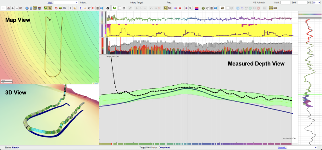
ZoneVu is a cloud-based geologic software and operations system for geosteering and completions. It was designed to unite asset teams in the way Greenlake needed for a technically demanding U-turn drilling campaign in the Delaware Basin. Their geology and engineering teams used ZoneVu to integrate 3D seismic, fault interpretations, and live operational data across every well.
The goal: Maintain precise spatial awareness of the bit’s location in true 3D, enable instant hazard detection, and keep every team member working from the same live picture — from rig floor to office.
Understanding the Risks
Wellbore Instability, Torque & Drag
- Acute build and turn sections in U-turn wells create elevated risk for wellbore instability, torque and drag, and stuck pipe. Even minor deviations from the planned trajectory can escalate BHA wear, force unplanned bit trips, or require costly sidetracks and remedial intervention that erode well economics before first production.
Reservoir Exit from Spatial Misrepresentation
- Conventional geosteering displays rely on 2D projections — vertical section views in TVD or TVT — that cannot fully capture the true three-dimensional complexity of U-turn well paths. Critical spatial relationships, such as proximity to faults, bedding plane orientation, or approaching geohazards, may be missed or misinterpreted entirely. The result is increased risk of drilling errors, out-of-zone excursions, and unplanned exits from the reservoir.
Team Misalignment During Complex Steering Events
- U-turn wells require split-second decisions from geology, drilling, and engineering teams simultaneously. Without a shared, automatically updating view of the bit’s location and geologic context, teams working from different data sources or stale interpretations can’t react fast enough — compounding risk at the moments that matter most.
ZoneVu's 3D Clarity Keeps Every Team Member Ahead of the Bit
"ZoneVu brought real-time geologic context and 3D clarity to every screen. It enabled our team to stay aligned and execute our technical strategies seamlessly."
Samuel Simmons, Director of Geoscience
ZoneVu Frac™ Data Integration
Spatial Risk Identification and Hazard Avoidance
ZoneVu Alerts™ were configured to trigger when wells approached mapped faults, exited the target zone, or neared problematic geology — giving the drilling team time to adjust before costly events occurred. Geosteering in MD mode preserved the actual drilled length and three-dimensional trajectory throughout each well, ensuring that the sharp azimuth and inclination changes of the U-turn path were navigated with full spatial context rather than a projected approximation. By identifying and responding to geologic hazards in real time, Greenlake avoided the BHA damage, stuck pipe events, and reservoir exits that commonly affect U-turn drilling campaigns in the Delaware Basin.
BHA Performance:
By maintaining precise spatial awareness through the build and turn sections, the initial four U-turn wells were each completed on a single BHA — no unplanned bit trips through the most demanding sections of the well path. In a basin known for abrasive conditions and technically demanding laterals, this is a standout operational benchmark that directly reflects the quality of real-time steering decisions made throughout each well.
Preventing Reservoir Exit: ZoneVu Keeps the Bit in Zone
During the six-well campaign, Greenlake’s multidisciplinary teams worked from the same automatically updating ZoneVu display — geoscientists, drilling engineers, and contractors all aligned in real time without version lag, data handoffs, or parallel interpretations to reconcile. When conditions changed, the entire team saw it simultaneously and could act on it immediately. ZoneVu’s unified display eliminated the communication gaps that typically slow down steering decisions in complex trajectory wells, keeping production exposure in the reservoir and minimizing out-of-zone excursions across all six wells.
Well Placement and Cost Performance:
With fewer out-of-zone excursions than comparable well campaigns in the basin, Greenlake delivered superior reservoir contact across the entire program. The first well came in 17% under AFE, with cost savings driven by rapid geosteering response, smoother drilling, and fewer trips. Across all six wells, average cost performance came in 11% under AFE — a direct result of precise well placement and the team alignment that ZoneVu made possible.
Results
- Six U-turn horizontal wells drilled to date, with several more in the upcoming drill schedule
- Initial four U-turn wells drilled with only one BHA per well — a standout achievement for a technically demanding basin
- First well drilled was 17% under AFE, with savings driven by rapid geosteering response, smoother drilling, and fewer trips
- 11% under AFE on average across all six U-turn wells drilled
- Superior well placement and fewer out-of-zone excursions, keeping production on or above type curve across all six wells
- ZoneVu’s live 3D display kept every stakeholder engaged and aligned — on every screen, 24/7 — from rig to office